Pulling it all together
All four boundaries
You have now stood at all four boundaries of the Australian Plate. They look completely different from each other: a deep ocean trench at Sunda, an explosive volcano at Hunga Tonga, a long fault ripping across mountain country in New Zealand, and an underwater ridge running between Australia and Antarctica. But they are all part of the same plate, doing the same thing in different ways. Time to step back and look at the whole picture.
The Australian Plate and its four boundaries
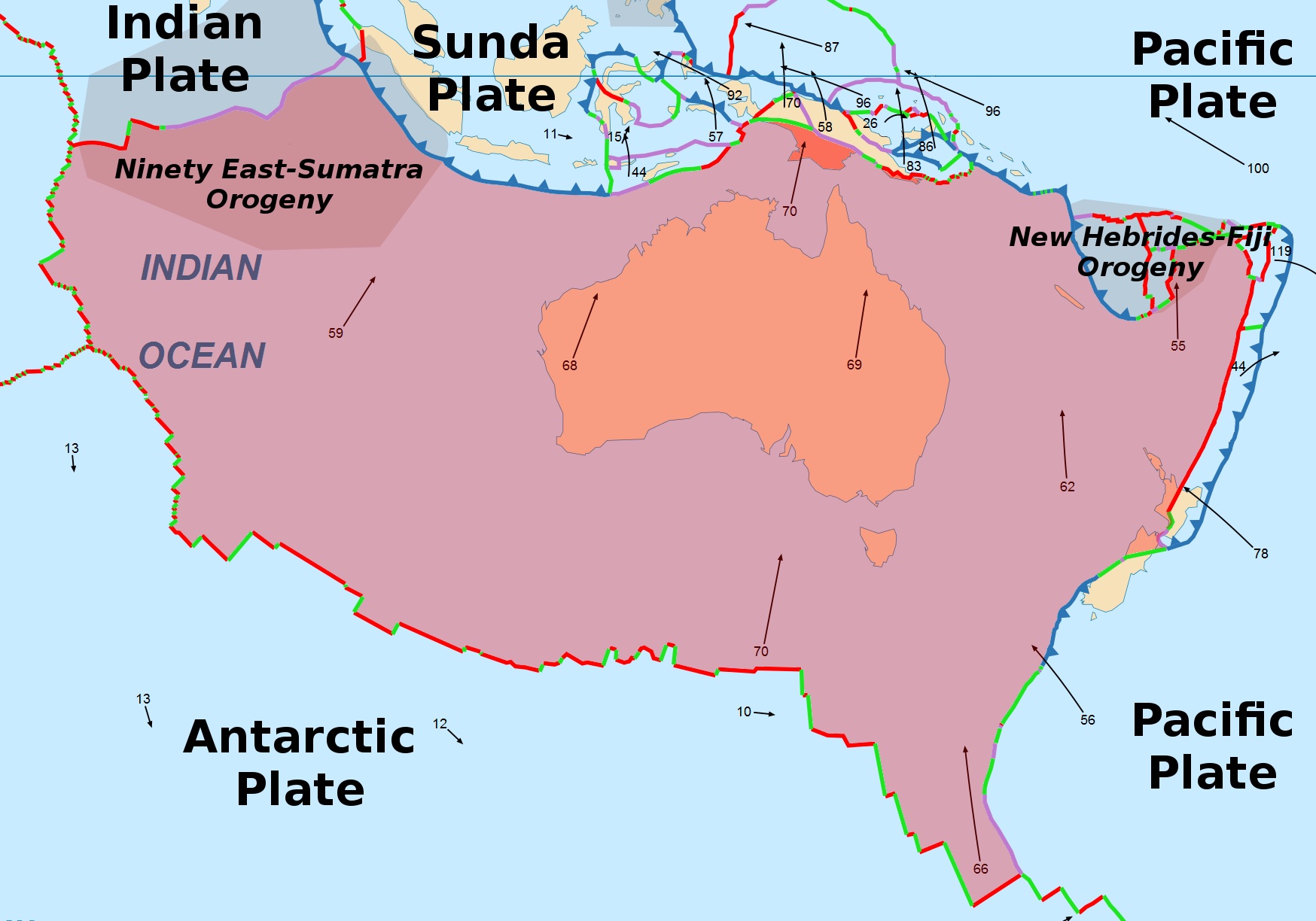
All four boundaries you have studied, mapped on the Australian Plate. The plate (centre, pink) is pushed northward at about 70 mm per year by the Southeast Indian Ridge (south). That northward motion is what drives convergence at Sunda (north-west) and Tonga (north-east) and the transform sliding at the Alpine Fault (south-east, New Zealand). The numbers on the arrows are plate motion rates in millimetres per year. Map: Wikimedia Commons (File:AustralianPlate.png).
The four cases at a glance
Sunda Trench
- Boundary type
- Convergent (oceanic-continental subduction)
- Plates
- Indo-Australian going under Eurasian
- Motion
- ~70 mm/yr, mostly perpendicular into the trench
- Crust
- Destroyed (the oceanic edge of the Indo-Australian Plate goes deep into the mantle)
- Signature event
- 2004 Sumatra-Andaman earthquake and Indian Ocean tsunami
Tonga-Kermadec Trench
- Boundary type
- Convergent (oceanic-oceanic subduction)
- Plates
- Pacific going under Australian (both oceanic; the older, denser Pacific sinks)
- Motion
- ~240 mm/yr, one of the fastest subduction zones on Earth
- Crust
- Destroyed, plus new volcanic crust grows on the Australian side
- Signature event
- 2022 Hunga Tonga-Hunga Ha'apai eruption
Alpine Fault
- Boundary type
- Transform (dextral strike-slip)
- Plates
- Australian and Pacific sliding past each other
- Motion
- ~30 mm/yr along the fault; Australian to the NE, Pacific to the SW
- Crust
- Neither created nor destroyed (mostly preserved)
- Signature event
- 2011 Christchurch earthquake (on a related fault); next major Alpine Fault rupture overdue
Southeast Indian Ridge
- Boundary type
- Divergent (mid-ocean ridge)
- Plates
- Australian and Antarctic pulling apart
- Motion
- ~70 mm/yr total spreading; almost all of it on the Australian side
- Crust
- Created (new oceanic crust forms continuously at the ridge axis)
- Signature event
- No famous disaster. The whole ridge is underwater. But it is the engine driving everything else.
The four boundaries are one connected system.
It is tempting to think of the four boundaries as four separate stories. Sunda is the tsunami one. Tonga is the volcano one. The Alpine Fault is the New Zealand earthquake one. The Southeast Indian Ridge is the obscure underwater one. Four cases, four chapters, end of unit.
That is not what is happening. The four boundaries are one connected system, and the Southeast Indian Ridge is what powers it. Every year, hot rock rises into the gap between the Australian and Antarctic Plates, cools, and adds new oceanic crust to the southern edge of the Australian Plate. The plate gets longer at the bottom, and the whole continent shifts north as a result. Around 70 millimetres a year. About the rate fingernails grow. Continuous, for the past 25 million years and counting.
That northward push is what makes everything else happen. Push Australia north into Asia, and you force the Indo-Australian Plate to dive beneath the Eurasian Plate: that is the Sunda Trench. Push the Pacific Plate aside, and somewhere in the north-east the older, denser Pacific seafloor gets shoved down faster than anywhere else on Earth: that is Tonga. Slide Australia past New Zealand at an angle, and the two plates grind along a 600 km fault that locks and releases every 250-300 years: that is the Alpine Fault.
Stop the ridge spreading, and the engine goes silent. Over millions of years, Australia would slow down. Sunda and Tonga would lose the force pushing the plates together. The Alpine Fault would stop accumulating stress. The Earth would still be hot inside, and mantle convection would carry on, but this specific plate, on this specific journey, would change. Plate tectonics is not a set of independent local stories. It is one global circulation pattern, and the four boundaries you have just studied are four faces of the same plate moving through it.
Budj Bim and the Gunditjmara record.
The four boundaries you have studied are happening right now. Earthquakes, eruptions, and slip events have been recorded in recent decades with seismometers and GPS. But plate tectonic processes have been operating for far longer than the instruments that measure them, and scientific observation of these processes extends back much further too.
In south-western Victoria, the volcano known as Budj Bim (formerly Mount Eccles) has erupted multiple times, with eruptions dated to more than 30,000 years ago and as recently as around 7,000 years ago. The lava flows travelled over 50 km west and south toward the sea, reshaping the drainage of the region. These eruptions were witnessed by the ancestors of the Gunditjmara people, the Traditional Owners of this Country. The events are recorded in Gunditjmara oral tradition: an ancestral creator-being, Budj Bim (meaning "high head"), revealed himself in the landscape. The mountain is his head, and the basalt stones are his teeth.
The Gunditjmara then used the volcanic landscape itself, constructing an aquaculture system of channels, weirs and dams in the basalt to trap kooyang (short-finned eel, Anguilla australis). This system is at least 6,600 years old and supported large, semi-permanent settlements with around 200 known stone house sites. In July 2019, the Budj Bim Cultural Landscape became the first Australian site to be inscribed on the UNESCO World Heritage List purely for its Aboriginal cultural significance.
Budj Bim extends the picture you have built in two ways. First, the four cases in this resource are all at plate boundaries; Budj Bim is intra-plate, sitting near the middle of the Australian Plate, formed by mantle activity beneath the plate itself. Plate tectonic processes are not limited to plate edges. Second, the scientific observation of these processes is far older than the modern instruments we use today. Gunditjmara people observed, recorded, and lived with these geological events for tens of thousands of years.
Apply what you now understand.
The Southeast Indian Ridge has been spreading for around 25 million years. Imagine that, tomorrow, it stopped. The mantle stopped rising into the gap. No new crust is being added to the Australian Plate's southern edge anymore.
Predict what would happen at the other three boundaries over the next 10 million years. What would change at Sunda? At Tonga? At the Alpine Fault? Why?
Write at least 40 characters to enable Submit.
The plates have not stopped moving. They never do.
Plate tectonics is one of the most powerful ideas in science. Once you can see that the surface of the Earth is broken into rigid plates and that those plates move, every mountain range, every earthquake zone, every volcanic island chain, every ocean basin starts to make sense. Most of what looks like geography is actually the visible result of tectonic motion.
The four boundaries of the Australian Plate are a good place to learn this because they show all three motion types (convergent, transform, divergent), they happen close to home, and they connect to events you may have heard about (the Boxing Day tsunami, the Hunga Tonga eruption, the Christchurch earthquake). But the pattern is global. Every plate has multiple boundaries, every boundary belongs to a network, and the whole system is driven by the same heat escaping from inside the Earth.
This resource was a starting point. The next step is yours.
What this resource is based on
Curriculum
- Australian Curriculum, Assessment and Reporting Authority (ACARA). (2024). Australian Curriculum v9.0: Science Understanding, Year 8 (AC9S8U03). Retrieved from https://v9.australiancurriculum.edu.au
Images and maps
- Case 1 (world plates map): U.S. Geological Survey. (n.d.). This Dynamic Planet: World map of volcanoes, earthquakes, impact craters, and plate tectonics. Public domain.
- Case 2 (Tonga-Kermadec regional map): Adapted from Bird, P. (2003). An updated digital model of plate boundaries. Geochemistry, Geophysics, Geosystems, 4(3), 1027. https://doi.org/10.1029/2001GC000252
- Case 3 (Alpine Fault from the ISS): NASA Earth Observatory / International Space Station crew photograph. Public domain.
- Case 3 (Alpine Fault aerial view): NASA. Public domain.
- Case 3 (Aoraki / Mt Cook): Photograph via Watchers.News (2015), New insight into New Zealand's Alpine Fault. Likely original photograph by Rob Suisted (naturespic.com), depicting Aoraki / Mt Cook from above Sealy Tarns, Hooker Valley. Used with permission or under fair use for educational purposes. Source URL: https://watchers.news/2015/09/06/new-insight-into-new-zealands-alpine-fault-central-south-island-more-vulnerable-than-first-thought/
- Case 3 (New Zealand tectonic map): Norton, M. Tectonic map of New Zealand showing the Australian-Pacific plate boundary, fault systems, and Pacific Plate motion vectors relative to the Australian Plate (in mm/year). Wikimedia Commons. Plate motion data consistent with DeMets, C., Gordon, R. G., & Argus, D. F. (2010). Geologically current plate motions. Geophysical Journal International, 181(1), 1-80.
- Case 4 (Southeast Indian Ridge bathymetry): Pimvantend. (2012). Seir.png: Southeast Indian Ridge bathymetry with earthquake epicenters and fracture zones. Wikimedia Commons. Public domain (data sources: NOAA ETOPO2 bathymetry, NOAA BOUNDARY/LINEATIO and QUAKES datasets; map produced with GMT, Lambert projection). Retrieved from https://commons.wikimedia.org/wiki/File:Seir.png
- Synthesis (Australian Plate region): AustralianPlate.png. Wikimedia Commons. Map of the Australian Plate showing all four boundaries with plate-motion vectors in mm/year. Retrieved from https://commons.wikimedia.org/wiki/File:AustralianPlate.png
Scientific sources for case content
- 2004 Sumatra-Andaman earthquake (Case 1): Lay, T., et al. (2005). The great Sumatra-Andaman earthquake of 26 December 2004. Science, 308(5725), 1127-1133.
- 2022 Hunga Tonga eruption (Case 2): Proud, S. R., Prata, A. T., & Schmauß, S. (2022). The January 2022 eruption of Hunga Tonga-Hunga Ha'apai volcano reached the mesosphere. Science, 378(6619), 554-557. Plus NOAA NCEI eruption summary (2022) and ReliefWeb situation reports.
- Alpine Fault rupture history and chronology (Case 3): Howarth, J. D., et al. (2018). A 2000 yr rupture history for the Alpine Fault derived from Lake Ellery, South Westland, New Zealand. GSA Bulletin, 130(7-8), 1191-1205. Supporting context from the Science Learning Hub and GNS Science.
- 2011 Christchurch earthquake (Case 3 anchor): GeoNet / GNS Science. (2011). M6.3 Christchurch earthquake, 22 February 2011. Retrieved from https://www.geonet.org.nz
- Southeast Indian Ridge spreading rates (Case 4): DeMets, C., Gordon, R. G., & Argus, D. F. (2010). Geologically current plate motions. Geophysical Journal International, 181(1), 1-80.
- Marie Tharp and the mapping of the mid-ocean ridges (Case 4 sidebar): Felt, H. (2012). Soundings: The Story of the Remarkable Woman Who Mapped the Ocean Floor. Henry Holt and Co. Plus Heezen, B. C., & Tharp, M. (1957). Physiographic diagram of the North Atlantic Ocean. Geological Society of America. Marie Tharp's archived papers are held by the Library of Congress.
- Budj Bim Cultural Landscape and Gunditjmara observation (Synthesis): UNESCO World Heritage Centre. (2019). Budj Bim Cultural Landscape (inscription 1577). Retrieved from https://whc.unesco.org/en/list/1577. Plus Department of Climate Change, Energy, the Environment and Water (DCCEEW). World Heritage Places: Budj Bim Cultural Landscape. Australian Government. Eruption chronology: Matchan, E. L., Phillips, D., Jourdan, F., & Oostingh, K. (2020). Early human occupation of southeastern Australia: New insights from 40Ar/39Ar dating of young volcanoes. Geology, 48(4), 390-394. Cultural and historical context drawn from Gunditj Mirring Traditional Owners Aboriginal Corporation and the National Museum of Australia.
Pedagogical framework
- Predict-Observe-Explain sequence: White, R. & Gunstone, R. (1992). Probing Understanding. Falmer Press.
- Formative assessment with model answers: Black, P. & Wiliam, D. (1998). Inside the black box: Raising standards through classroom assessment. Phi Delta Kappan, 80(2), 139-144.
- Universal Design for Learning: CAST. (2018). Universal Design for Learning Guidelines version 2.2. Retrieved from https://udlguidelines.cast.org