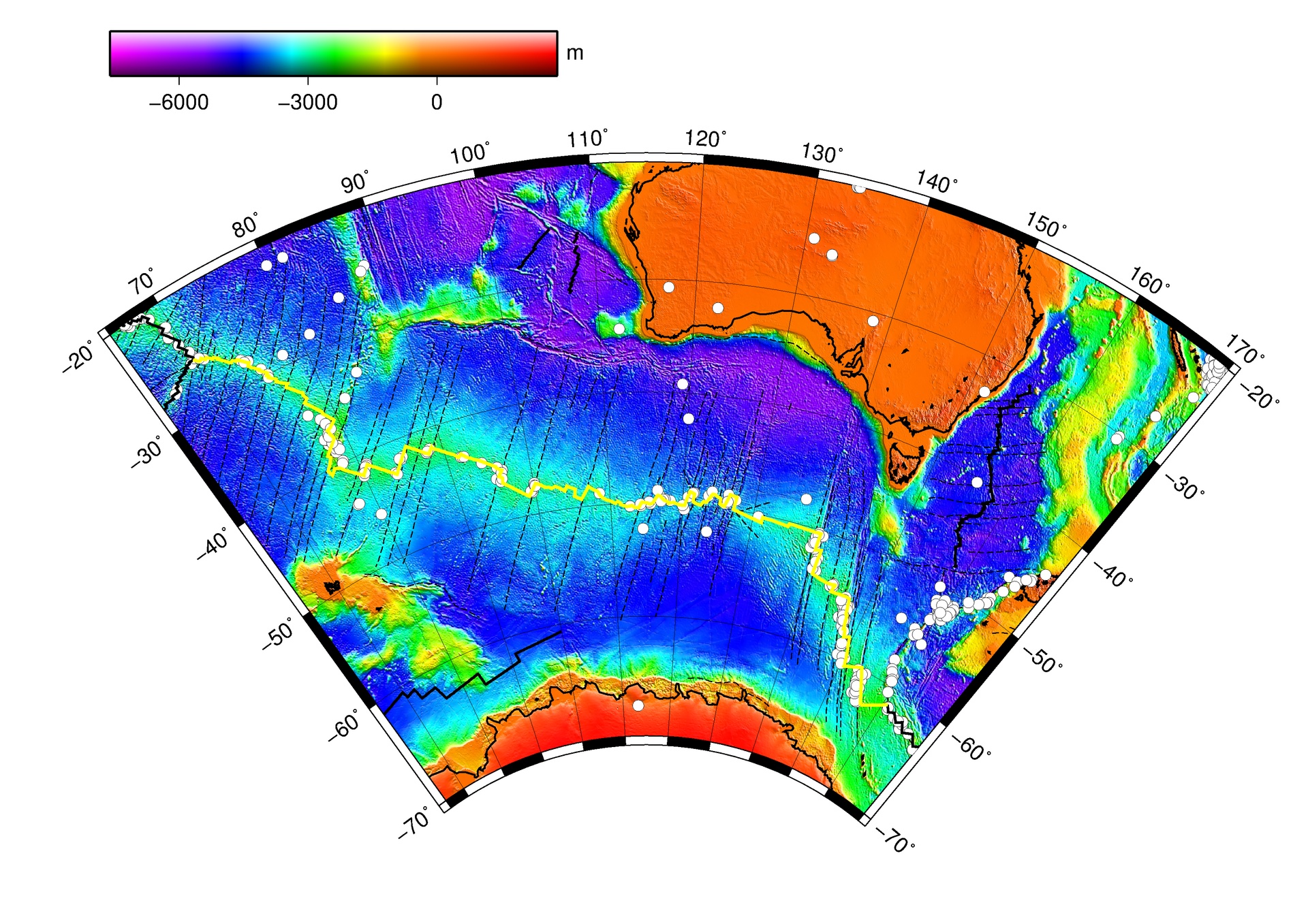
Australia (top right) and Antarctica (bottom) on a bathymetric map of the Southern Ocean. The yellow line is the Southeast Indian Ridge, the plate boundary running roughly east to west between the two continents along the seafloor. It is about 6,000 km long and sits almost entirely under 3 km of seawater. We will come back to this map after the animation to look at it more carefully. Map: Pimvantend (2012), Wikimedia Commons, public domain. Data: NOAA ETOPO2 and earthquake catalogue.
Move south-west. About 3,000 km south of the Alpine Fault, the Australian Plate meets a third partner: the Antarctic PlateThe tectonic plate that carries the Antarctic continent and most of the surrounding Southern Ocean floor. It is one of the largest plates and is almost entirely stationary in an absolute reference frame.. Here the two plates are pulling apart, not sliding past or pushing into one another. This is a divergentA plate boundary where two plates move away from each other. As they separate, hot rock from the mantle rises into the gap and cools to form new oceanic crust. Most divergent boundaries on Earth sit underwater along mid-ocean ridges. boundary, and it is the engine that pushes Australia northward into everything you have already studied.
The situation at the Southeast Indian Ridge
Now apply what you know.
Here's what's true at this specific boundary:
→
A new plate joins the story. The Southeast Indian Ridge separates the Australian Plate (north) from the Antarctic PlateThe tectonic plate that carries the Antarctic continent and most of the surrounding Southern Ocean floor. One of the largest plates on Earth, and almost completely stationary in an absolute reference frame. (south). The boundary itself runs along the seafloor, thousands of kilometres from either continent. Both plates carry only oceanic crustThe crust under the oceans. Made of denser, darker rock (mostly basalt) than continental crust. Typically only 7 to 10 km thick. along this stretch of boundary.
⇅
The plates pull apart, not into or past each other. Hot rock from the mantle rises into the gap and cools to form new oceanic crust. This is a divergentA plate boundary where two plates move away from each other. Hot rock from the mantle rises into the gap, cools, and forms new oceanic crust. Most divergent boundaries on Earth sit underwater along mid-ocean ridges. boundary. Crust is created here, the opposite of what happens at Tonga (where it is destroyed) or at Sunda (where it is forced down into the mantle).
⏱
This is the engine. The plates separate at about 70 mm/yr in total, roughly the rate fingernails grow. Because the Antarctic Plate is almost stationary, nearly all of that motion belongs to the Australian Plate moving north. This single boundary is what pushes Australia toward Asia (Sunda), into the Pacific (Tonga), and past New Zealand (the Alpine Fault). Everything else in this resource is downstream of this slow, continuous spreading.
Take a moment. You have already seen plates pushing into one another and sliding past one another. What do you reckon happens when they pull apart?
Step 1: Predict
What do you think will happen at this boundary?
Try starting: "I think this because…"
Choose an option above and write at least 5 characters of reasoning.
What a scientist would predict
You predictedYour reasoning
The Southeast Indian Ridge is a divergent boundary, so the prediction is that the two plates pull apart and that new oceanic crust forms in the gap. As the Australian and Antarctic Plates separate, hot rock from the mantle rises into the gap (because there is less pressure above it), partially melts, and solidifies on the seafloor as fresh basalt. No crust is being destroyed here. Crust is being created. Continuously.
If you picked "plates slide past each other sideways": that is correct for the Alpine Fault (Case 3) but not the dominant motion here. The Southeast Indian Ridge does have some short transform offsets along its length (the small step-overs in the ridge line), but the primary motion is perpendicular to the boundary, not parallel. The plates move apart, not past each other.
If you picked "one plate slides under the other": that is correct for Sunda (Case 1) and Tonga (Case 2) but not here. There is no subduction at the Southeast Indian Ridge. Crust is being made here, not destroyed, and there is no trench, no volcanic arc, and no deep earthquakes. This is the opposite of what happens at a subduction zone.
Predictions are not graded. The point was to commit to a guess before watching the animation, so that what you see next has something to push against.
Step 2: Observe
Watch what actually happens.
Time scale: roughly 1 million years of seafloor spreading compressed into 6 seconds. Spread exaggerated for clarity.
At a divergent boundary, the plates pull apart. As they separate, hot rock from the mantle rises into the gap because there is less pressure above it. Some of that rising rock melts and becomes magma. The magma reaches the seafloor at the ridge axis, cools rapidly in the cold ocean water, and solidifies into fresh basalt: brand new oceanic crust. The plates keep moving apart, the new crust gets carried away from the ridge, and more magma rises behind it. Over the past 25 million years, the Southeast Indian Ridge has built almost the entire seafloor between Australia and Antarctica this way.
Seeing the Southeast Indian Ridge
Most plate boundaries on land you can photograph from the air or from space (as you saw at the Alpine Fault). This one is hidden under 3 km of seawater along its entire 6,000 km length, so we visualise it through bathymetry: a colour-coded map of how deep the seafloor is.
The ridge as bathymetry. Colours show seafloor depth from 0 m (red/orange, land) down to about −6,000 m (deep purple). Australia sits at the top right, Antarctica along the bottom edge. The yellow line traces the Southeast Indian Ridge across the seafloor between them, about 3 km below the ocean surface. The white dots are earthquakes recorded along the boundary, showing that it is still seismically active even though no one lives near it. The ridge runs almost the full width of the visible map. Map: Pimvantend (2012), Wikimedia Commons, public domain. Data: NOAA ETOPO2 and earthquake catalogue.
Step 3: Explain
Now make sense of what you saw.
Try starting: "My prediction was… What I actually saw was… This means that…"
Write at least 15 characters to enable Submit (0/15).
Here's one way to explain this
Your explanation
At the Southeast Indian Ridge, the Australian and Antarctic Plates pull apart from each other. As they separate, hot rock from the mantle rises into the gap because the pressure above it is reduced. Some of that rising rock melts into magma. The magma reaches the seafloor at the ridge axis, cools rapidly in the cold ocean water, and solidifies into fresh basalt: brand new oceanic crust. This is the opposite of what happens at Tonga or Sunda, where crust is forced down into the mantle. Here it is being made. The whole seafloor between Australia and Antarctica has been built this way over the past 25 million years, and the same process is what pushes Australia northward by about 70 mm per year.
What makes a strong answer here:
Identifies the boundary as divergent (or a spreading centre, or a mid-ocean ridge): the plates pull apart.
Explains the mechanism: hot mantle rock rises into the gap, partially melts, cools at the seafloor, and forms new oceanic crust.
States the consequence: oceanic crust is created here, the opposite of what happens at a subduction zone.
Connects to Australia's northward motion (or to "this is why the other boundaries are doing what they do"). The synthesis claim is what makes this case the closer for the resource.
This is one possible way to express the explanation, not the only correct answer. If your wording is different but you covered the same key ideas, you have it. The point of this step is to put the mechanism into your own words and then check that against a model.
Why this matters
This ridge is the engine.
Australia is moving north at roughly 7 centimetres per year. That is one of the fastest a continent has moved in geological history. The Southeast Indian Ridge is what makes that happen. Every year, hot rock rises into the gap between the Australian and Antarctic Plates, cools, and adds new crust to the southern edge of the Australian Plate. The plate gets longer at its southern edge, and the whole continent shifts north as a result.
Everything you have seen in this resource sits downstream of this slow, continuous spreading. The 2004 Sumatra earthquake (Case 1), the Hunga Tonga eruption (Case 2), the 2011 Christchurch earthquake (Case 3), and the Alpine Fault waiting to rupture again: all of it is powered by the ridge. The ridge itself does not make headlines. It is mostly underwater, far from anyone. It has no famous disaster attached to it. But it is the reason Australia is colliding with Asia at Sunda, why the Pacific Plate is being forced down at Tonga, and why the Alpine Fault has accumulated 480 km of offset since the boundary formed.
Plate tectonics is one connected system. If you know what is happening at the Southeast Indian Ridge, you understand why the other three boundaries are doing what they do. The plates have not stopped moving. They never do.
A scientist who saw this
Marie Tharp and the rift valley
The boundary you have just studied is hidden under 3 km of seawater. So is the Mid-Atlantic Ridge, on the other side of the Indian Ocean. Both are part of the same global system of mid-ocean ridges that wraps the Earth like a seam. We can map these structures today using satellite altimetry, but in the 1950s the work was done by hand.
Marie Tharp (1920 to 2006) was an American geologist and cartographer at Columbia University's Lamont Geological Observatory. Women were not allowed on research vessels at the time, so Tharp worked from depth readings collected by male colleagues at sea. Plotting those readings across the Atlantic, she identified a deep V-shaped rift valley running down the middle of the Mid-Atlantic Ridge. Her colleague Bruce Heezen at first dismissed the finding as "girl talk." Tharp was right. The rift valley was direct visual evidence of seafloor spreading, and her physiographic maps (with Heezen, first published in 1957) helped make the theory of plate tectonics visually undeniable.
Every mid-ocean ridge on Earth, including the one you have just studied, has a structure she helped the world see.
Marie Tharp's papers are held by the Library of Congress. See Felt (2012), Soundings: The Story of the Remarkable Woman Who Mapped the Ocean Floor.
Up next →Synthesis: pulling it all togetherContinue